
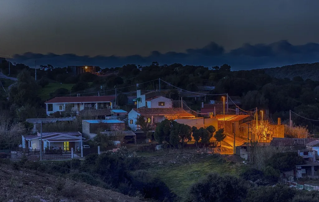

Sirri belongs to the municipality of Carbonia, yet it encourages a view of the area beyond the familiar image of a mining city. Its small cluster of homes and the church of Santa Lucia introduce a rural story: buildings gathered among the hills, open ground and a religious landmark with modest, almost domestic proportions. The night photograph shows this scale particularly clearly, with pools of light along the lanes and houses set within a much larger landscape.
Use the directory entry for Santa Lucia church in Sirri to locate the settlement. The reference belongs to Carbonia even when an address names the hamlet directly. Churches dedicated to Saint Lucy occur in many places, so check for Sirri as well as Santa Lucia when choosing a destination. This prevents a familiar saint's name from sending you to the wrong point on the map.
A settlement older than the mining city
Cagliari's National Archaeological Museum describes Sirri as a medieval settlement that developed around the church. This concerns the history of the place, rather than dating every wall visible today. A religious building may retain its role while undergoing repairs, changes and rebuilding. It would therefore be misleading to assign the whole structure shown in the photographs to the Middle Ages simply because the settlement has medieval origins.

The distinction between continuity of place and changes in appearance is part of Sirri's interest. Carbonia's foundation in the twentieth century does not mark the beginning of settlement across its municipal territory. Here, the rural setting offers a different starting point. Instead of looking only for structures associated with industry, attention shifts towards the relationship between homes, the land around them and a shared religious landmark.
Reading the nineteenth-century descriptions
The municipality's report on rural settlements reproduces an account by Angius and Casalis. It describes Sirri's boddeu near Santa Lucia as approximately twelve furriadroxius associated with the Bellisai family. This is historical evidence, not a present-day census. The number should not be used to count today's houses, and the family reference does not establish who occupies particular properties now.
Terms such as boddeu and furriadroxiu belong to the vocabulary of rural settlement in Sulcis. In the report, they help explain an organisation of the countryside in which family connections and agricultural activity were important. Encountering these words before visiting makes it easier to understand how a small group of homes could acquire a recognisable identity without the size or layout of a larger urban centre.
Santa Lucia's porch and small bell structure
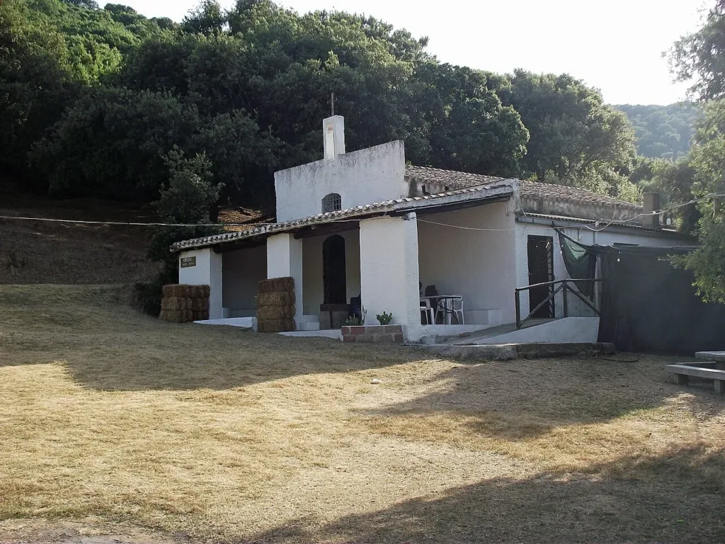
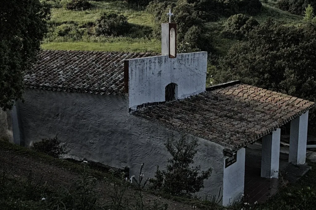
The two church photographs included here, taken in 2010 and 2019, draw attention to the tiled roof, covered entrance and small bell structure rising above the roofline. Pale surfaces at the front contrast with darker side walls. Surrounding vegetation contributes to the composition. The building is not presented against an open monumental backdrop, but within an intimate green setting that helps explain its visual character.
The viewpoints offer complementary information. The frontal photograph clarifies the relationship between the entrance and its covered space. The oblique view better reveals the building's depth and the arrangement of the roof slopes. These are observations from dated photographs, not confirmation of its current condition. Their purpose is to suggest recognisable features to examine without inventing construction materials, building campaigns or details of restoration that the images cannot establish.

Approaching an inhabited place
A visit to Sirri calls for the consideration appropriate to a small residential community. Public routes and domestic entrances may be close together. Keep to public roads, avoid stepping into courtyards to obtain a photograph and leave entrances clear. A wider view can communicate the relationship between homes and hillside without making residents, windows or private belongings the subject of the visit.
Check local opening arrangements before expecting to enter Santa Lucia. A church appearing on a map does not imply continuous visitor access. Likewise, a rural lane suggested by a navigation app should not automatically be treated as a public walking trail. For other places within the municipality, the Carbonia blog collection offers separate articles. Sirri's particular contribution is the opportunity to recognise a rural settlement history that precedes the foundation of the modern city.