
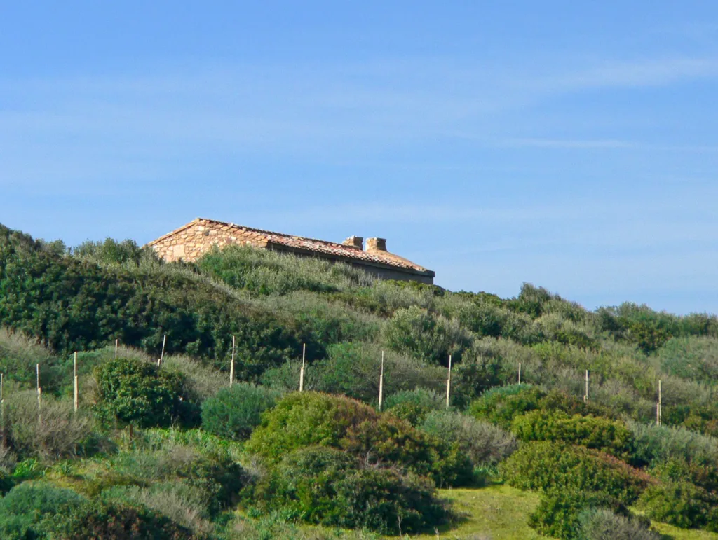

Santa Maria di Flumentepido stands on a small rise in the countryside of Carbonia. In the view from the north, its roof emerges above a band of vegetation, and the building almost seems absorbed into the slope. Looking more closely through the other photographs reveals the masonry, a narrow window and stone shafts beside the church. These features make it possible to recognise several periods within one small place.
The Santa Maria di Flumentepido directory entry locates the monument on the map. Search for its full name: this country church is not a generic destination in central Carbonia. Its history belongs to the rural territory that preceded the mining town, and the isolated position shown in the pictures is an essential part of its character.
A medieval presence in the countryside
The Ministry of Culture dates the Romanesque building to the eleventh century and connects it with Judge Orzocco Torchitorio I’s donation to the Benedictines of Montecassino in 1066. The regional guide to the Sulcis Iglesiente includes it among the historical landmarks in the settlements north of Carbonia. These references give the small church a chronological depth that its simple forms might otherwise conceal.
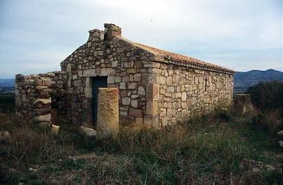

A medieval date does not mean that every visible stone belongs to the same building campaign. A donation records a relationship between people, institutions and property; interpreting a wall involves identifying materials and alterations. Both perspectives are useful at Santa Maria. The connection with Montecassino explains a historical relationship, while the reused shafts outside point towards an earlier material history.
The frontage and the side wall
The oblique photograph shows a gabled front, a rectangular entrance and a small bell-supporting feature at the top. Along the side, blocks of different sizes create an irregular pattern interrupted by the narrow window. The building forms a compact volume: its roof runs along its length, and the side wall makes its depth apparent in a way that a purely frontal view cannot.
This compact form corresponds to the single-nave plan without an apse described in the ministry’s entry. There is no need to assign symbolic meaning to every irregularity in the masonry. The differences between the doorway, side opening and roofline already distinguish entrance, lighting and covering. The images reproduced here are archive views, rather than evidence of a recent inspection of the building’s present condition.
Milestones turned into supports
Entry 3266 in the municipality’s archaeological heritage register identifies a Roman settlement beneath the church site and considers a sacred function probable. It also records four milestones reused in the portico, relating them to an important junction on the Via Sulcitana. The religious interpretation therefore remains a hypothesis, while the reuse of stone objects is central to understanding the site’s layers of history.
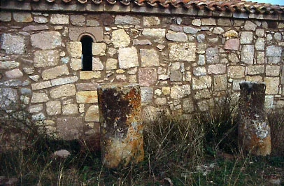
The photograph of the southern wall makes that change tangible. Two shafts stand in front of the wall, distinct from its fabric of smaller blocks. A milestone begins as a marker beside a road; reused as a support, it becomes part of a different architectural arrangement. Its shape can remain recognisable after its function changes. Being beside the church does not establish that the position shown is its original location along the Roman route.

A portico and its surviving elements
The ministry’s presentation dates the addition of a portico built with reused materials to the seventeenth century. In Wikibiro’s photographs, described in the archive captions as views from 1994, the supports appear in the open air. Comparing the historical description with the image suggests an arrangement more extensive than the enclosed building visible in the photograph. It does not justify inventing its number of bays, heights or roof structure.
The difference between a column and a wall is particularly helpful here. A wall encloses a space; a sequence of supports can define a sheltered area while leaving it open to the outside. Observing the shafts beside the front and along the flank helps explain why a portico would have changed the relationship between the church and its surroundings. Elements standing apart from the main enclosure still belong to the complex’s history.
A landmark along rural routes
The municipality’s study of the medaus, or rural settlements, reproduces nineteenth-century descriptions by Vittorio Angius and recalls pilgrims passing near Santa Maria. It also cautions against automatically equating the older settlements called Barbusi and Flumentepido with their present-day counterparts. The church thus becomes a relatively stable reference within a landscape whose place names, inhabited nuclei and routes have undergone change.
Before visiting, confirm access to the land and any opening of the building with local contacts: historical accounts are not an admission timetable. The map identifies the location, while the photographs prepare three specific observations: the position on the hill, the relationship between the frontage and side wall, and the reused materials outside. For a different chapter of the town’s religious architecture, the blog has a separate guide to San Ponziano Church.